Surveying is the core of what we do. Regardless of the size and scope of your venture, we take ownership from start to finish, negotiating and advocating for you to deliver approval outcomes.
There are stages of subdivision and we can help with all. We will provide you with an indication of subdivision costs to help with your feasibility
You may want to subdivide your suburban property, update your title, transform rural land to urban, or create a commercial estate. We've significant experience with council processes and procedures that can save you time and money by guiding you through the consenting process.
Surveying is the core of what we do. Regardless of the size and scope of your venture, experienced professionals will take ownership from start to finish, negotiating and advocating for you to ensure approval outcomes are delivered. Your requirements may be as simple as confirming features such as house height compliance with a restricted covenant or property boundaries, or as complex as subdividing a rezoned block into hundreds of new titles. Our team will meet your needs
• Precision surveys
• 3D topographical surveys
• Infrastructure projects including roading and rail
• Resource & Land Use Consent applications
• Construction and building set-out
• Monitor settlement of structures
• As-built surveying once construction is complete
• Fee simple, unit title, and strata title developments for small and large developments
• Removal of limitations on old titles
• Legalisation surveys for the Crown (eg road stopping)
There are stages of subdivision and we can help with all. We will provide you with an indication of subdivision costs to help with your feasibility
A. Scoping and feasibility: feasibility study can provide you with advice on the subdivision rules applicable to your land and your corresponding subdivision options. We can ensure what you are proposing is viable and advise on opportunities that will maximise returns.
B. Planning and resource consent: advise you whether your plans require a resource consent in the form of a subdivision consent or land use consent or both. If so, we will obtain the relevant consent on your behalf.
i. You may need a resource consent if you are doing something as straightforward as clearing vegetation on your property or erecting a sign, through to carrying out earthworks, creating a building platform or starting a commercial use of your building or land.
ii. You will need a subdivision consent whether you wish to alter your current boundary or carry out a large multi-lot development.
C. Civil engineering construction and design: whether it be earthworks to create a building platform or driveway, roading, water supply, stormwater or wastewater drainage design, there will be the need for a civil engineering consultant. We can carry out the necessary design, source the necessary approvals (eg Watercare, Auckland Transport, Council) and monitor the installation of these services prior to seeking the necessary certifications.
D. Power, telecommunications & water is likely to be required for your consent if new lots are proposed. We can help you coordinate with energy and telecommunications providers and Watercare to ensure their requirements are met to service your property.
E. Cadastral survey: When works are complete, our surveyors will step in and carry out the cadastral survey to establish and ground mark the boundaries for your subdivision. The necessary Cadastral Survey Dataset (CSD) is then created in Landonline and submitted for ‘Survey Approval’ once Council certifications are issued.
F. Council approvals: Under sections 223 and 224c of the Resource Management Act 1991, two Council approvals are required to confirm that your subdivision complies with the conditions of the resource consent granted. We have established relationships with local Council facilitating ease of approvals, enabling the development to be completed.
G. Issue of new titles: Direct liaison with your solicitor who will lodge the necessary legal documentation to have titles issued will enable a seamless
We will provide you with an indication of subdivision costs free of charge, to help you budget your project. Footprint aims to deliver a superior service based on full transparency of costs, regular client communication and deliverables within time frames.
You may want to subdivide your suburban property, update your title, transform rural land to urban, or create a commercial estate. Significant experience with council processes and procedures can save you time and money by guiding you through the consenting process.
If you are wanting a minor alteration to your property boundary or you are creating several additional titles you will need a subdivision consent issued from the Council. We work in conjunction with planners, geotech and civil engineers with broad experience who will provide the necessary consents and give the direction & advice required in order to maximise your investment.
Services we can provide for you include:
• Feasibility studies, due diligence and scoping
• Planning and Resource Management advice
• Resource Consent Applications (RCA)
• Assessment of Environmental Effects (AEE)
• Subdivision covering fee-simple & unit titles
• Cross-lease to fee-simple conversions
• Cross-lease/flats plan updates
• Urban and rural subdivisions
• Commercial, retail, industrial, and mixed-use developments
• Council certifications
• Rights of way, Local Government Act
• Creation of necessary easements
• Project Management
We will provide you with an indication of subdivision costs free of charge, to help you budget your project. Footprint aims to deliver a superior service based on full transparency of costs, regular client communication and deliverables within time frames.


Typically, New Zealand Surveyors are involved in the following:
• Cadastral (Boundary) Surveys
• Topographical (site) surveys
• Building set-out
• As-built surveys of new infrastructure and buildings
• Subdivision design (Scheme plans)
• Resource consent applications
• Subdivision engineering design
• Project Management
A ‘topographical’ site survey will gather all the existing information of your site so an architect or building designer and civil engineer can design what’s needed in accordance with the existing landform, infrastructure and any restrictive covenants and Council rules. The field work will normally take 1-2 days of site work and another 1-2 days of data processing and production of plans.
Commonly referred to as a ‘topo’ survey, these are carried out to produce a digital model, which gives accurate information, often forming the basis for designing a house, designing a subdivision or some other form of development on land.
Footprint will visit your site, measure up what’s needed, including the overall ground surface, and then produce a clear and detailed ‘topo’ plan. You and any other consultants including architects can use the accurate data provided in both pdf and dwg digital format, as a base to the development of your property. The data would include land contours, significant vegetation, any buildings (including heights) and fencing, services and also any areas of legal rights overlying the land such as easements and covenants.
It is wise to have your boundaries ground marked before undertaking this work. You can then be sure that any structures (eg fences, walls driveways or buildings) will be correctly positioned in relation to the boundary, thus avoiding potentially costly disputes with neighbours and non-compliance with Council rules.
The only way to ensure your boundary marks are reliable is to have them checked by a Licensed Cadastral Surveyor. It is very common for pegs to have been moved or be incorrectly identified. Sometimes a brief discussion with a surveyor and review of the subject survey plans, you may be able to confirm the position of your boundary.
Cross-lease titles are based on undivided ownership of the underlying land and then reciprocal leases (cross leases) between the parties for the area that the buildings occupy. Exclusive use covenant areas are also utilised to define those areas that can be used by one or other party or jointly used areas (‘common’ areas).
This was often applied under earlier District Plans to allow easier compliance. Converting the cross-lease to fee-simple gives more independent rights and lifts the value of a title. All conversions of cross-lease tenure to fee-simple require the agreement of all current owners followed by a subdivision application to the Council. With all owners interested, costs may be shared. The conversion is similar to a normal subdivision, often with less conditions resulting in less costs, especially if services to each of the buildings are already independent. Feel free to discuss your requirements with us.
The term ‘cadastral’ originates from the Latin word ‘cadastre’ relating to the dimensions and location of land - Cadastre - Wikipedia.
In New Zealand, only a Licensed Cadastral Surveyor (LCS) can submit a cadastral survey to Land Information New Zealand (LINZ) to be legally approved.
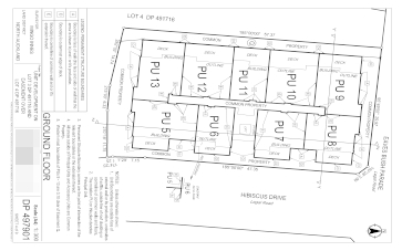
Often referred to as a Land Transfer Survey, a cadastral survey is required whenever legal property boundaries are being created, altered or determined. This might happen when you subdivide land; alter current property boundaries; create an easement or legal right over land; or simply need a refreshed legal record for the location of an existing boundary. Unit titles also require cadastral surveys. Unit titles are more commonly used for layered/multi-story ownership.
FootPrint has decades of experience and knowledge of New Zealand’s cadastral system and can cater for all the above with accurate and efficient outcomes. We will take care of all the details, seeking the necessary certifications from Council; marking the legal boundaries on-site; obtaining survey approval from Land Information New Zealand (LINZ), and liaising with your solicitor to have new land titles issued.
Local and Regional Councils control building construction and the use of land through their District Plans. Certain activities are permitted as of right, but some activities are controlled and to carry out these activities you require a resource consent. Activities that may require consent may be as simple as building slightly closer to your boundary than permitted, or it might be as complex as establishing a large commercial development.
A Licensed Cadastral Surveyor is the only person who can submit the final cadastral records to LINZ. However, we believe that by involving a surveyor early in the planning of your subdivision, you will achieve significantly better outcomes. That’s because: a) surveyors historically have been responsible for all facets of land development so they are familiar with the pitfalls (and the shortcuts), and can steer your proposal through the development process. b) surveyors are needed throughout land development from the initial feasibility, the topographical survey, the preparation of subdivision scheme plans for consent, the set-out and as-built and certification of new structures, the creation of the new legal titles and easements.
When you need surety your home, commercial building or services are built in the right place, you need a surveyor. We are experts at taking designs and plans and precisely setting them out for construction. This can be crucial to ensure your building complies with set-back and height restrictions or resource consent conditions, or to ensuring that a storm-water or foul sewer design performs as planned. Council also require a Licensed Cadastral Surveyor to certify all consented construction.
A Record of Title was previously referred to as a ‘Certificate of Title’ (CT) and is the record of legal interests in a parcel of land. It will show the title reference, who owns the land and any other interests or encumbrances on the land including liens, encroachments, easements, leases, restrictive covenants and protective covenants. Some are beneficial to the title, while others are restraining, providing rights to other parties or restricting the use of your land. A title reference for North Auckland may be NA 12/345 or simply 6 digits for more recent titles along with a legal description of the land. eg Lot 2 DP 12345.
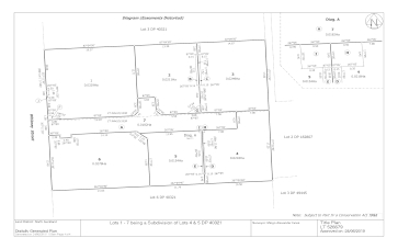
A Deposited Plan (DP) is a survey plan showing the creation of new legal boundaries including easements. Most parcels of land in New Zealand are described as a particular ‘Lot’ number on a DP e.g. Lot 1 DP345678. This description is called the ‘appellation’ or ‘legal description’. This information can be found on your rates information.
Some examples are 'Section 1 Block VII Mata Survey District' for Crown land or 'Kaiti 313A6B2' for Māori land or 'Lot 1 DP 12345' for general land. When a new survey plan is created, surveyors create the survey plan and send it to LINZ to gain ‘Survey Approval’. The legal representatives of the land owner then deal with the legal team at LINZ to create the updated title.
Land Information New Zealand (LINZ) are the government department responsible for producing and holding the records of land ownership.
“What do we want from a consultant - quality, on time, on budget. And of course integrity. Mingo has delivered on all fronts.”

“Mingo provides a wealth of survey knowledge. He is professional and a pleasure to work with. I would definitely recommend him”

"I highly recommend his expertise to any person looking for an Land surveyor. His ability to tackle any problem with a warm smile, is remarkable ."